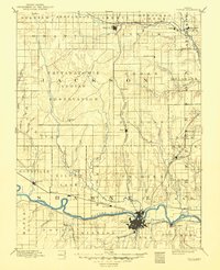
1894 Map of Topeka
USGS Topo · Published 1949About this map
The Pottawatomie Indian Reservation dominates the heart of this landscape, reflecting a pivotal era of land tenure in Jackson County. Surveyed by J.H. Renshawe and E.T. Perkins, the topography reveals a dense network of prairie tributaries like Big Soldier Creek and Cross Creek feeding into the Kansas River valley. This 19th-century study illustrates the rapid expansion of the steam era, where the Union Pacific Railroad and the Atchison Topeka and Santa Fe Railroad converge at Topeka, fueling the growth of outlying rail stops such as Silver Lake, Rossville, and Menoken. To the north, the Kansas Central Railroad serves the trade center of Holton, while smaller settlements like Agency and Mayetta are positioned along the developing north-south corridors. The map provides an essential look at the transition from Indigenous territory to a complex grid of townships and commercial transport lines.
Find a feature on this map
70 named features on this map. Tap any name to fly to it.
Don’t see what you’re looking for? This feature index may not catch every label — zoom into the map to look around manually.
Map Details
Editions of this 1894 Topeka Map
5 editions found

Other maps of this area

1885 · Eskridge
USGS Topo · 1:125,000

1885 · Atchison
USGS Topo · 1:125,000

1885 · Lawrence
USGS Topo · 1:125,000

1886 · Oskaloosa
USGS Topo · 1:125,000

1888 · Oskaloosa
USGS Topo · 1:125,000

1888 · Atchison
USGS Topo · 1:125,000

1888 · Hiawatha
USGS Topo · 1:125,000

1889 · Burlingame
USGS Topo · 1:125,000

1889 · Seneca
USGS Topo · 1:125,000

1889 · Wamego
USGS Topo · 1:125,000