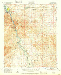
1951 Map of Topock
USGS Topo · Published 1951About this map
The Colorado River carves a dramatic path through the Mohave Mountains on this 1951 survey, creating the sharp bends and rocky passages of Mohave Canyon. This corridor serves as a vital transportation artery, featuring the Atchison Topeka and Santa Fe railroad and the historic National Old Trails Road crossing near Topock. The mapping reflects the mid-century landscape of the lower Colorado, including the Havasu Lake National Wildlife Refuge and the Fort Mohave Indian Res. Small-scale mining operations like the Jackpot Mine and Boulder Mine are scattered throughout the arid uplands, while the river's edge shows early aviation and water management infrastructure, including the Topock Landing Field and a Gaging Sta. Landforms such as Cathedral Rock and Castle Rock define the shoreline of Havasu Lake.
Find a feature on this map
42 named features on this map. Tap any name to fly to it.
Don’t see what you’re looking for? This feature index may not catch every label — zoom into the map to look around manually.
Map Details
Editions of this 1951 Topock Map
2 editions found

Other maps of this area

1903 · Needles
USGS Topo · 1:125,000

1904 · Needles Special
USGS Topo · 1:125,000

1911 · Parker
USGS Topo · 1:125,000

1927 · Yucca
USGS Topo · 1:62,500

1927 · Buck Mountains
USGS Topo · 1:62,500

1929 · Buck Mountains
USGS Topo · 1:62,500

1929 · Yucca
USGS Topo · 1:62,500

1943 · Giers Basin
USGS Topo · 1:62,500

1943 · Topock
USGS Topo · 1:62,500

1943 · Whipple Mts.
USGS Topo · 1:62,500