
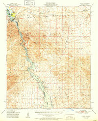
1951 Map of Topock
USGS Topo · Published 1951About this map
The Colorado River carves a dramatic path through the Mohave Mountains and Chemehuevi Mountains in this early 1950s survey of the Arizona-California border. The landscape is a study in Western infrastructure and natural conservation, featuring the sprawling Havasu Lake National Wildlife Refuge alongside the industrial utility of the Atchison Topeka and Santa Fe railroad and the National Old Trails Road.
Find a feature on this map
44 named features on this map. Tap any name to fly to it.
Don’t see what you’re looking for? This feature index may not catch every label — zoom into the map to look around manually.
Map Details
Editions of this 1951 Topock Map
2 editions found
Other maps of this area

1903 · Needles
USGS Topo · 1:125,000

1904 · Needles Special
USGS Topo · 1:125,000

1911 · Parker
USGS Topo · 1:125,000

1927 · Yucca
USGS Topo · 1:62,500

1927 · Buck Mountains
USGS Topo · 1:62,500

1929 · Buck Mountains
USGS Topo · 1:62,500

1929 · Yucca
USGS Topo · 1:62,500

1943 · Giers Basin
USGS Topo · 1:62,500

1943 · Topock
USGS Topo · 1:62,500

1943 · Whipple Mts.
USGS Topo · 1:62,500