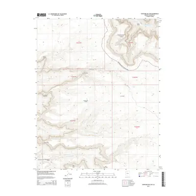
2014 Map of Topocoba Hilltop
USGS Topo · Published 2014About this map
The Colorado River carves through the northeastern corner of this Coconino County terrain, where the churning Forster Rapids mark the river's path within Grand Canyon National Park. This 2014 survey documents a landscape defined by dramatic verticality and isolation, centered on the remote outpost at Topocoba Hilltop. The map reveals a complex network of canyons and drainage systems, including the deeply etched Topocoba Gorge and the winding Lee Canyon, which feed into the larger regional basins. Local water sources are scarce, indicated by features like Topocoba Spring and Chiefs Tank, which have historically served as vital points for travelers and livestock in this arid environment. Significant landmarks such as Mt Spoonhead and the broad Pasture Wash offer orientation points across the high plateaus, while the descent into Cataract Canyon - Havatagvitch Canyon to the southwest highlights the area's intricate geological transition toward Havasu Creek.
Find a feature on this map
24 named features on this map. Tap any name to fly to it.
Don’t see what you’re looking for? This feature index may not catch every label — zoom into the map to look around manually.
Map Details
Editions of this 2014 Topocoba Hilltop Map
This is the sole edition of this map. No revisions or reprints were ever made.
Other maps of this area

1886 · Kaibab
USGS Topo · 1:250,000

1953 · Grand Canyon
USGS Topo · 1:250,000

1957 · Grand Canyon
USGS Topo · 1:250,000

1958 · Grand Canyon
USGS Topo · 1:250,000

1960 · Grand Canyon
USGS Topo · 1:250,000

1962 · Kanab Point
USGS Topo · 1:62,500

1962 · Havasupai Point
USGS Topo · 1:62,500
1962 · Powell Plateau
USGS Topo · 1:62,500

1962 · Supai
USGS Topo · 1:62,500

1984 · Grand Canyon
USGS Topo · 1:100,000