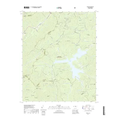
2019 Map of Topton
USGS Topo · Published 2019About this map
The Nantahala National Forest dominates this landscape where four North Carolina counties—Graham, Cherokee, Macon, and Clay—converge amidst the southern Appalachian peaks. Centered on the sprawling Nantahala Lake, the terrain rises sharply from the Nantahala River valley into the Tusquitee Mountains and the Snowbird Mountains. The map documents a network of high-elevation gaps and ridges, including Shinbone Ridge, London Bald, and Wolf Creek Gap. Settlement is concentrated at the northern edge in Topton and Rhodo, and to the east at Aquone, while the interior is defined by recreation and timberlands. Long-distance hikers can trace the path of the Bartram Trail as it winds through Diamond Valley and across Sutherland Gap, while the Rim Trail skirts the southwestern ridges near Signal Bald. This survey provides a precise look at the drainage patterns of numerous branches and forks, such as Roaring Fork and Indian Camp Br, that feed into the central reservoir.
Find a feature on this map
132 named features on this map. Tap any name to fly to it.
Don’t see what you’re looking for? This feature index may not catch every label — zoom into the map to look around manually.
Map Details
Editions of this 2019 Topton Map
This is the sole edition of this map. No revisions or reprints were ever made.
Other maps of this area

1933 · Bushnell
USGS Topo · 1:62,500

1935 · Rainbow Springs
USGS Topo · 1:24,000

1935 · Robbinsville
USGS Topo · 1:24,000

1935 · Shooting Creek
USGS Topo · 1:24,000

1935 · Burningtown Bald
USGS Topo · 1:24,000

1935 · Topton
USGS Topo · 1:24,000

1935 · Wayah Bald
USGS Topo · 1:48,000

1935 · Andrews
USGS Topo · 1:24,000
1935 · Hayesville
USGS Topo · 1:24,000

1936 · Wesser
USGS Topo · 1:24,000