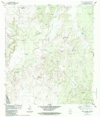
1984 Map of Tordillo Creek
USGS Topo · Published 1984About this map
The Rio Grande forms the international boundary in this arid South Texas landscape, where the United States of America meets Mexico. This 1984 survey reveals a territory defined by complex drainage systems, including San Lorenzo Creek, Tordillo Creek, and Pañuelo Creek, which feed into the river. Human presence is sparse and focused on ranching and resource extraction, anchored by Tordillo Camp and supported by numerous water management features like Vat Trap Tank and Fifteen Hundred Tank. The geography is marked by isolated landmarks such as the Aura Windmill and Ramon Windmill, alongside evidence of the region's petroleum industry with several Oil Well and Gas Well sites. A Landing Strip near the center of the quadrangle suggests the logistical challenges of reaching these remote borderlands.
Find a feature on this map
37 named features on this map. Tap any name to fly to it.
Don’t see what you’re looking for? This feature index may not catch every label — zoom into the map to look around manually.
Map Details
Editions of this 1984 Tordillo Creek Map
This is the sole edition of this map. No revisions or reprints were ever made.
Other maps of this area

1923 · Palafox
USGS Topo · 1:62,500

1929 · Cotulla
USGS Topo · 1:125,000

1940 · San Loranzo Creek
USGS Topo · 1:62,500

1940 · Chupadera
USGS Topo · 1:62,500

1953 · Crystal City
USGS Topo · 1:250,000

1955 · Crystal City
USGS Topo · 1:250,000

1956 · Laredo
USGS Topo · 1:250,000

1958 · Eagle Pass
USGS Topo · 1:250,000

1961 · Crystal City
USGS Topo · 1:250,000

1965 · Eagle Pass
USGS Topo · 1:250,000