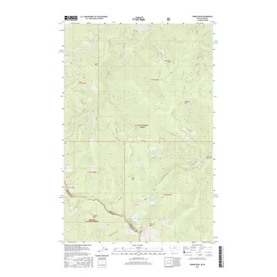
2017 Map of Torino Peak
USGS Topo · Published 2017About this map
The Bitterroot Range defines the high-altitude divide between Shoshone County and Mineral County in this 2017 survey of the Idaho-Montana border. This high-country landscape is shaped by the headwaters of the N Fork Little Joe Cr and S Fork Little Joe Cr, with the terrain rising to prominent heights at Torino Peak and Sunset Peak. The map provides a detailed view of the remote boundary land within the Lolo National Forest and St Joe National Forest, where the complex topography includes isolated features like Diamond Lake and Cliff Lake. Steep drainages such as Hendrickson Gulch and Ann Arbor Gulch cut through the ridges, while the S Fork Little Joe Rd and Dry Cr Rd No 342 trace the narrow corridors through the forest. The presence of named points like Washout Point and Eagle Cliff highlights the verticality of the region, marking a wilderness area characterized by significant elevation changes and seasonal watercourses.
Find a feature on this map
38 named features on this map. Tap any name to fly to it.
Don’t see what you’re looking for? This feature index may not catch every label — zoom into the map to look around manually.
Map Details
Editions of this 2017 Torino Peak Map
This is the sole edition of this map. No revisions or reprints were ever made.
Other maps of this area

1918 · St Regis
USGS Topo · 1:125,000

1919 · St. Regis
USGS Topo · 1:125,000

1956 · St Regis
USGS Topo · 1:62,500

1956 · Wallace
USGS Topo · 1:250,000

1957 · Illinois Peak
USGS Topo · 1:62,500

1957 · Haugan
USGS Topo · 1:62,500

1957 · Simmons Peak
USGS Topo · 1:62,500

1960 · Wallace
USGS Topo · 1:250,000
1988 · St Regis
USGS Topo · 1:24,000
1988 · Sherlock Peak
USGS Topo · 1:24,000