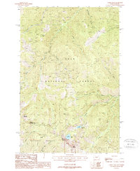
1988 Map of Torino Peak
USGS Topo · Published 1988About this map
Torino Peak and Little Joe Mountain dominate this high-altitude landscape along the border of Mineral and Shoshone counties. This 1980s provisional survey documents the steep drainage basins within the Lolo National Forest and St Joe National Forest, where numerous creeks including Little Joe Creek and Torino Creek carve deep into the mountain ridges. The map captures a wilderness area defined by difficult access, recording only a few specific human interventions such as a Footbridge over Torino Creek and an isolated Prospect near the base of Sunset Peak. For those studying the geography of the Bitterroot range, the map provides precise locations for remote alpine features like Diamond Lake, Cliff Lake, and Moore Lake, as well as the transition from Montana into Idaho along the divide marked by St Joe Ridge.
Find a feature on this map
32 named features on this map. Tap any name to fly to it.
Don’t see what you’re looking for? This feature index may not catch every label — zoom into the map to look around manually.
Map Details
Editions of this 1988 Torino Peak Map
This is the sole edition of this map. No revisions or reprints were ever made.
Other maps of this area

1918 · St Regis
USGS Topo · 1:125,000

1919 · St. Regis
USGS Topo · 1:125,000

1956 · St Regis
USGS Topo · 1:62,500

1956 · Wallace
USGS Topo · 1:250,000

1957 · Illinois Peak
USGS Topo · 1:62,500

1957 · Haugan
USGS Topo · 1:62,500

1957 · Simmons Peak
USGS Topo · 1:62,500

1960 · Wallace
USGS Topo · 1:250,000
1988 · St Regis
USGS Topo · 1:24,000
1988 · Sherlock Peak
USGS Topo · 1:24,000