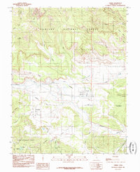
1985 Map of Torrey
USGS Topo · Published 1985About this map
Torrey and Teasdale serve as the primary hubs in this high-desert landscape, where human settlement is defined by the availability of water. The Torrey Canal and various irrigation structures illustrate the engineering required to sustain agriculture on Poverty Flat and the surrounding benches. This 1985 survey, based on field work from the late 1970s, captures the intersection of the Fishlake National Forest and Dixie National Forest, showing a transition from the wooded elevations of The Ant Hill down to the carved canyons and mesas. The Fremont River provides the lifeblood for the valley, while water management is further evidenced by upland features like Coleman Reservoir and Torrey Allotment Reservoir No 2. Distinctive geological formations like Meeks Mesa, Velvet Ridge, and Hells Hole dominate the northern and eastern reaches of the quadrangle.
Find a feature on this map
30 named features on this map. Tap any name to fly to it.
Don’t see what you’re looking for? This feature index may not catch every label — zoom into the map to look around manually.
Map Details
Editions of this 1985 Torrey Map
2 editions found
Other maps of this area

1885 · Fish Lake
USGS Topo · 1:250,000

1896 · Fish Lake
USGS Topo · 1:250,000

1952 · Notom 2 NW
USGS Topo · 1:24,000

1952 · Loa 1 SE
USGS Topo · 1:24,000

1952 · Notom 3 NW
USGS Topo · 1:24,000

1952 · Notom 2 SE
USGS Topo · 1:24,000

1952 · Notom 2 SW
USGS Topo · 1:24,000

1952 · Notom 2 NE
USGS Topo · 1:24,000

1952 · Notom 3 NE
USGS Topo · 1:24,000

1952 · Grover
USGS Topo · 1:62,500