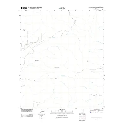
2011 Map of Tortolita Mountains
USGS Topo · Published 2011About this map
Tortolita Mountains anchor this arid landscape of the Sonoran Desert, where deep canyons and seasonal washes dictate the placement of human activity. The map reveals a traditional ranching economy represented by the Palo Verde Ranch, Barriles Ranch, and McKenzie Ranch. Water is the defining resource here, traced through isolated points like Cochie Spring, Bass Spring, and Cottonwood Spring, along with landmarks like the Riddle Windmill and Crow Windmill. To the northwest, the Owl Head Buttes rise above a sparse network of roads such as Silverian Rd and Guild Rd. The southern portion of the quadrangle is dominated by the complex terrain of Fresnal Canyon and Bass Canyon, illustrating how the desert's topography has historically shaped movement and settlement in Pima County.
Find a feature on this map
41 named features on this map. Tap any name to fly to it.
Don’t see what you’re looking for? This feature index may not catch every label — zoom into the map to look around manually.
Map Details
Editions of this 2011 Tortolita Mountains Map
This is the sole edition of this map. No revisions or reprints were ever made.
Other maps of this area

1904 · Tucson
USGS Topo · 1:125,000

1905 · Tucson
USGS Topo · 1:125,000

1911 · Winkelman
USGS Topo · 1:125,000

1913 · Winkelman
USGS Topo · 1:125,000

1934 · Tucson Mountains
USGS Topo · 1:125,000

1934 · Newman Peak
USGS Topo · 1:125,000

1947 · Cortaro
USGS Topo · 1:62,500

1956 · Tucson
USGS Topo · 1:250,000

1957 · Cortaro
USGS Topo · 1:62,500
1957 · Mount Lemmon
USGS Topo · 1:62,500