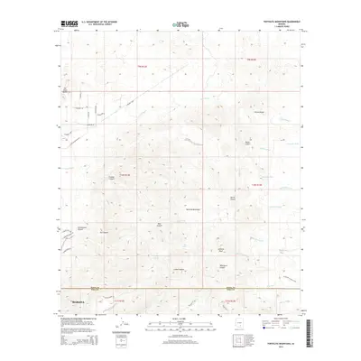
2014 Map of Tortolita Mountains
USGS Topo · Published 2014About this map
The Tortolita Mountains dominate this landscape, where the Pima and Pinal county lines meet north of Marana. This 2014 survey documents a complex network of canyons and washes that define the area's hydrology and topography, including Jeffords Peak and the prominent Falcon Divide. The map detail reveals how modern recreational paths like the Wild Burro Trail and Honeybee Canyon Loop now trace the same terrain as older landmarks like Cottonwood Spring and Cochie Spring. While the southwestern corner shows the suburban expansion of Marana with streets such as S Carpenter Ranch Rd and E Sunset Hills Rd, the majority of the sheet remains characterized by drainage systems like Guild Wash and Indian Well Wash. This transition from organized residential blocks to the untamed drainages of Dry Canyon and Wild Burro Canyon illustrates the ongoing intersection of Arizona’s desert wilderness and its growing metropolitan fringe.
Find a feature on this map
49 named features on this map. Tap any name to fly to it.
Don’t see what you’re looking for? This feature index may not catch every label — zoom into the map to look around manually.
Map Details
Editions of this 2014 Tortolita Mountains Map
This is the sole edition of this map. No revisions or reprints were ever made.
Other maps of this area

1904 · Tucson
USGS Topo · 1:125,000

1905 · Tucson
USGS Topo · 1:125,000

1911 · Winkelman
USGS Topo · 1:125,000

1913 · Winkelman
USGS Topo · 1:125,000

1934 · Tucson Mountains
USGS Topo · 1:125,000

1934 · Newman Peak
USGS Topo · 1:125,000

1947 · Cortaro
USGS Topo · 1:62,500

1956 · Tucson
USGS Topo · 1:250,000

1957 · Cortaro
USGS Topo · 1:62,500
1957 · Mount Lemmon
USGS Topo · 1:62,500