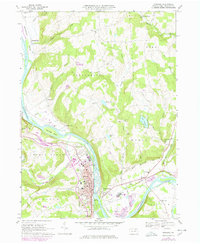
1967 Map of Towanda
USGS Topo · Published 1978About this map
The Susquehanna River carves a deep valley through Bradford County, anchoring a landscape defined by riverside settlements and narrow upland runs. The community of Towanda serves as the regional hub, showing a concentrated street grid that includes the High School, Morrow Sch, and the St Agnes Sch. Industrial footprints are evident in the numerous Gravel Pits and the Quarry near Quarry Glen, while the Conrail line tracks the river's western bank. Beyond the river flats, the terrain rises into the hills of Sheshequin and Wysox townships, where older rural patterns persist at Ghent and Myersburg. Notable landmarks like Lake Wesauking and the Fairgrounds near South Towanda suggest a mix of recreational and agricultural utility that characterized this part of Pennsylvania during the mid-to-late 20th century.
Find a feature on this map
59 named features on this map. Tap any name to fly to it.
Don’t see what you’re looking for? This feature index may not catch every label — zoom into the map to look around manually.
Map Details
Editions of this 1967 Towanda Map
2 editions found
Other maps of this area

1923 · Towanda
USGS Topo · 1:62,500

1926 · Towanda
USGS Topo · 1:62,500

1939 · Sayre
USGS Topo · 1:62,500

1942 · Sayre
USGS Topo · 1:62,500

1943 · Towanda
USGS Topo · 1:62,500

1943 · Monroeton
USGS Topo · 1:62,500

1943 · Powell
USGS Topo · 1:62,500

1945 · Powell
USGS Topo · 1:62,500

1948 · Sayre
USGS Topo · 1:62,500

1954 · Williamsport
USGS Topo · 1:250,000