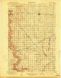
1897 Map of Tower
USGS Topo · Published 1914About this map
The Sheyenne River cuts a deep, winding valley through the eastern Dakota prairies, creating a stark geographic contrast to the high, flat plateaus that define most of this 1890s landscape. This survey captures a pivotal era of railroad expansion and pioneer settlement, with the Northern Pacific Main Line and the Minneapolis St. Paul and Sault Ste. Marie R. R. dictating the growth of towns like Valley City and Fingal. Beyond the rail hubs, the map traces the early township structure, including Thordenskjold and Raritan, where small communities like Kathryn and Nome were establishing themselves. Researchers will find interest in the documented locations of frontier landmarks such as Ft. Ransom and the numerous small station stops like Lanona and Lucca that once served the sprawling agrarian economy of Barnes and Cass counties.
Find a feature on this map
58 named features on this map. Tap any name to fly to it.
Don’t see what you’re looking for? This feature index may not catch every label — zoom into the map to look around manually.
Map Details
Editions of this 1897 Tower Map
3 editions found
Other maps of this area

1895 · Lamoure
USGS Topo · 1:125,000

1895 · Casselton
USGS Topo · 1:125,000

1897 · Tower
USGS Topo · 1:125,000

1897 · Eckelson
USGS Topo · 1:125,000

1897 · Casselton
USGS Topo · 1:125,000

1907 · Wyndmere
USGS Topo · 1:125,000

1918 · La Moure
USGS Topo · 1:125,000

1952 · Grand Forks
USGS Topo · 1:250,000

1952 · New Rockford
USGS Topo · 1:250,000

1953 · Jamestown
USGS Topo · 1:250,000