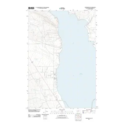
2011 Map of Townsend NE
USGS Topo · Published 2011About this map
Canyon Ferry Lake dominates this landscape along the Missouri River valley, where the water's edge is lined with recreational infrastructure. The western shore features the Canyon Ferry Airport and a cluster of traveler amenities including the Silos Campground and Silos RV Park. The transport network here reflects a mix of modern access and older routes, with names like Stagecoach Ln and Pay Dirt Rd hinting at the region's mining and transit history. On the eastern shore, the Fairview Cemetery sits near Duck Creek, providing a fixed point of local genealogy. Agricultural and water management systems are evident through the Broadwater Missouri Canal and several named water sources such as Antelope Springs and Whitehorse Creek, which flow toward the reservoir.
Find a feature on this map
32 named features on this map. Tap any name to fly to it.
Don’t see what you’re looking for? This feature index may not catch every label — zoom into the map to look around manually.
Map Details
Editions of this 2011 Townsend NE Map
This is the sole edition of this map. No revisions or reprints were ever made.
Other maps of this area

1886 · Fort Logan
USGS Topo · 1:250,000

1948 · White Sulphur Springs
USGS Topo · 1:250,000

1950 · Canyon Ferry
USGS Topo · 1:62,500

1950 · Townsend
USGS Topo · 1:62,500

1950 · Duck Creek Pass
USGS Topo · 1:62,500

1958 · White Sulphur Springs
USGS Topo · 1:250,000

1961 · White Sulphur Springs
USGS Topo · 1:250,000

1965 · White Sulphur Springs
USGS Topo · 1:250,000

1966 · Diamond City
USGS Topo · 1:24,000
1972 · Canyon Ferry SW
USGS Topo · 1:24,000