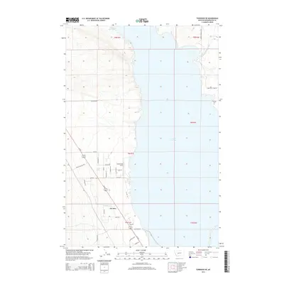
2014 Map of Townsend NE
USGS Topo · Published 2014About this map
Canyon Ferry Lake dominates the central landscape of this Broadwater County region, where the water meets a series of residential developments and irrigation networks. Along the western shoreline, the settlement of The Silos serves as a focal point near the Canyon Ferry Airport, reflecting the area's mid-century transition toward recreation and light aviation. The landscape is defined by a grid of named local roads such as Ab Cook Rd and Stagecoach Ln, while the presence of the Broadwater-Missouri Canal and Horse Cr on the eastern bank underscores the importance of water management in this arid stretch of Montana. Local history and genealogy are anchored by the Fairview Cem and the natural landmark of Antelope Springs, showing a mix of established sites and newer development patterns emerging around Us-287.
Find a feature on this map
37 named features on this map. Tap any name to fly to it.
Don’t see what you’re looking for? This feature index may not catch every label — zoom into the map to look around manually.
Map Details
Editions of this 2014 Townsend NE Map
This is the sole edition of this map. No revisions or reprints were ever made.
Other maps of this area

1886 · Fort Logan
USGS Topo · 1:250,000

1948 · White Sulphur Springs
USGS Topo · 1:250,000

1950 · Canyon Ferry
USGS Topo · 1:62,500

1950 · Townsend
USGS Topo · 1:62,500

1950 · Duck Creek Pass
USGS Topo · 1:62,500

1958 · White Sulphur Springs
USGS Topo · 1:250,000

1961 · White Sulphur Springs
USGS Topo · 1:250,000

1965 · White Sulphur Springs
USGS Topo · 1:250,000

1966 · Diamond City
USGS Topo · 1:24,000
1972 · Canyon Ferry SW
USGS Topo · 1:24,000