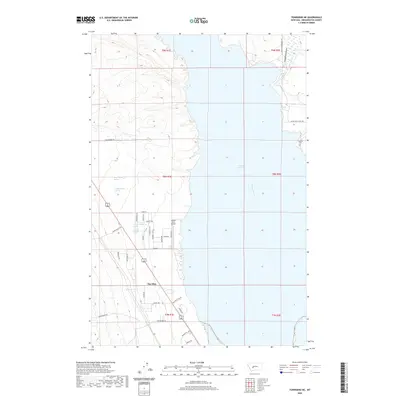
2020 Map of Townsend NE
USGS Topo · Published 2020About this map
Canyon Ferry Lake dominates this landscape, where the Missouri River is impounded along the eastern edge of the Big Belt Mountains. The settlement of The Silos sits near the southwestern shore, serving as a focal point for local activity alongside the Canyon Ferry Airport. The map documents a blend of water-driven infrastructure and historical land use, with the Broadwater-Missouri Canal and numerous named springs, such as Antelope Springs, illustrating the vital role of water management in this arid region. Roads like Paydirt Ln and Stagecoach Ln reflect the area's mining and frontier heritage, particularly near the mouth of Confederate Gulch. Genealogists may find interest in the Fairview Cem, located on a point overlooking the lake, providing a stationary point of reference amidst the changing water levels of the reservoir.
Find a feature on this map
42 named features on this map. Tap any name to fly to it.
Don’t see what you’re looking for? This feature index may not catch every label — zoom into the map to look around manually.
Map Details
Editions of this 2020 Townsend NE Map
This is the sole edition of this map. No revisions or reprints were ever made.
Other maps of this area

1886 · Fort Logan
USGS Topo · 1:250,000

1948 · White Sulphur Springs
USGS Topo · 1:250,000

1950 · Canyon Ferry
USGS Topo · 1:62,500

1950 · Townsend
USGS Topo · 1:62,500

1950 · Duck Creek Pass
USGS Topo · 1:62,500

1958 · White Sulphur Springs
USGS Topo · 1:250,000

1961 · White Sulphur Springs
USGS Topo · 1:250,000

1965 · White Sulphur Springs
USGS Topo · 1:250,000

1966 · Diamond City
USGS Topo · 1:24,000
1972 · Canyon Ferry SW
USGS Topo · 1:24,000