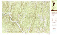
1984 Map of Townshend
USGS Topo · Published 1984About this map
West River carves a deep valley through the center of this Windham County landscape, anchoring a series of small riverside settlements and agricultural pockets. The village of Townshend serves as a local hub, home to the Leland and Gray High Sch and the distinctively named Town Hall Round School. The construction of the Townshend Reservoir near Rattlesnake Mountain reflects mid-century hydraulic engineering, altering the natural flow toward Harmonyville.
Find a feature on this map
54 named features on this map. Tap any name to fly to it.
Don’t see what you’re looking for? This feature index may not catch every label — zoom into the map to look around manually.
Map Details
Editions of this 1984 Townshend Map
2 editions found
Other maps of this area

1889 · Wilmington
USGS Topo · 1:62,500

1891 · Wilmington
USGS Topo · 1:62,500

1891 · Brattleboro
USGS Topo · 1:62,500

1893 · Brattleboro
USGS Topo · 1:62,500

1894 · Londonderry
USGS Topo · 1:62,500

1898 · Keene
USGS Topo · 1:62,500

1899 · Londonderry
USGS Topo · 1:62,500

1899 · Wilmington
USGS Topo · 1:62,500

1927 · Bellows Falls
USGS Topo · 1:48,000

1930 · Saxtons River
USGS Topo · 1:48,000