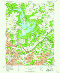
1957 Map of Towson
USGS Topo · Published 1958About this map
Loch Raven Reservoir dominates the northern landscape, its sprawling fingers fed by Gunpowder Falls and Merrymans Mill Branch. The mid-century expansion of Towson is evident in the dense residential clusters south of the water, including established neighborhoods like Stoneleigh, Rodgers Forge, and Anneslie. The area serves as a major institutional hub, shown through the campuses of Goucher College and Towson State Teachers College, alongside specialized facilities like the Sheppard Pratt Hospital and the Maryland Training School for Boys.
Find a feature on this map
232 named features on this map. Tap any name to fly to it.
Don’t see what you’re looking for? This feature index may not catch every label — zoom into the map to look around manually.
Map Details
Editions of this 1957 Towson Map
4 editions found
Other maps of this area

1893 · Gunpowder
USGS Topo · 1:62,500

1894 · Baltimore
USGS Topo · 1:62,500

1898 · Tolchester
USGS Topo · 1:125,000

1899 · Baltimore
USGS Topo · 1:62,500

1900 · Parkton
USGS Topo · 1:62,500

1901 · Belair
USGS Topo · 1:62,500

1901 · Gunpowder
USGS Topo · 1:62,500

1902 · Parkton
USGS Topo · 1:62,500

1903 · Tolchester
USGS Topo · 1:125,000

1904 · Baltimore
USGS Topo · 1:62,500