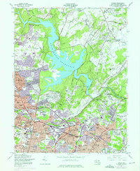
1957 Map of Towson
USGS Topo · Published 1976About this map
The expansive Loch Raven Reservoir dominates the northern half of this landscape, its fingers reaching toward Cambria and Blenheim while defining the geography of the surrounding valley. This era reveals the suburban densification of Baltimore County, where established communities like Lutherville and Timonium sit alongside newer developments such as Shetland Hills and Devonshire Forest. The map documents a significant concentration of institutions, including the sprawling grounds of Goucher College and Towson State Teachers College, as well as specialized facilities like the Sheppard-Pratt Hospital and Stella Maris Hospice.
Find a feature on this map
130 named features on this map. Tap any name to fly to it.
Don’t see what you’re looking for? This feature index may not catch every label — zoom into the map to look around manually.
Map Details
Editions of this 1957 Towson Map
4 editions found
Other maps of this area

1893 · Gunpowder
USGS Topo · 1:62,500

1894 · Baltimore
USGS Topo · 1:62,500

1898 · Tolchester
USGS Topo · 1:125,000

1899 · Baltimore
USGS Topo · 1:62,500

1900 · Parkton
USGS Topo · 1:62,500

1901 · Belair
USGS Topo · 1:62,500

1901 · Gunpowder
USGS Topo · 1:62,500

1902 · Parkton
USGS Topo · 1:62,500

1903 · Tolchester
USGS Topo · 1:125,000

1904 · Baltimore
USGS Topo · 1:62,500