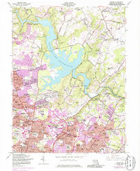
1957 Map of Towson
USGS Topo · Published 1986About this map
Loch Raven Reservoir dominates the landscape north of Baltimore, a massive water feature controlled by the Loch Raven Dam that shaped the surrounding development of rural and suburban Maryland. The map details the transition from rural estates and agricultural lands, like Carroll Manor and Hillendale Farms, to the densifying residential patterns of Towson and Lutherville. Institutional presence is significant here, featuring the Towson State Teachers College, Goucher College, and the sprawling Maryland Training School for Boys. Historically significant sites like the Hampton National Historical Site stand alongside specialized medical facilities including Sheppard-Pratt Hospital and the Notch Cliff Notre Dame Sanatorium. The winding route of the Maryland & Pennsylvania RR traces through the hills, while the 1970s-era purple revisions highlight the rapid post-war suburban growth spreading through Dulaney Village and Timonium.
Find a feature on this map
173 named features on this map. Tap any name to fly to it.
Don’t see what you’re looking for? This feature index may not catch every label — zoom into the map to look around manually.
Map Details
Editions of this 1957 Towson Map
4 editions found
Other maps of this area

1893 · Gunpowder
USGS Topo · 1:62,500

1894 · Baltimore
USGS Topo · 1:62,500

1898 · Tolchester
USGS Topo · 1:125,000

1899 · Baltimore
USGS Topo · 1:62,500

1900 · Parkton
USGS Topo · 1:62,500

1901 · Belair
USGS Topo · 1:62,500

1901 · Gunpowder
USGS Topo · 1:62,500

1902 · Parkton
USGS Topo · 1:62,500

1903 · Tolchester
USGS Topo · 1:125,000

1904 · Baltimore
USGS Topo · 1:62,500