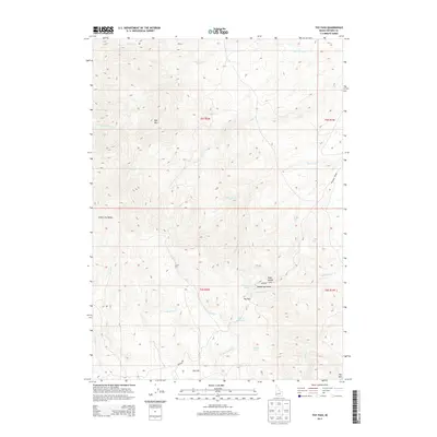
2013 Map of Toy Pass
USGS Topo · Published 2013About this map
Toy Pass serves as a central waypoint in this high-altitude landscape within Owyhee County, where the southern reaches of the Silver City Range meet a complex network of drainages. The topography is defined by significant elevations like Red Mtn and Toy Mtn, with the historic Bachman Grade providing a critical route through the uneven terrain. This 2013 survey illustrates the importance of water sources in the arid high country, documenting numerous points like Henderson Springs, Charity Spring, and Lineham Spring. The presence of Toy Flat and Hyde Saddle among the headwaters of N Fork Castle Cr and Buckaroo Cr highlights the area's geography of isolated flats and steep descents, essential for understanding the historical movement of livestock and travelers through this part of Idaho.
Find a feature on this map
31 named features on this map. Tap any name to fly to it.
Don’t see what you’re looking for? This feature index may not catch every label — zoom into the map to look around manually.
Map Details
Editions of this 2013 Toy Pass Map
This is the sole edition of this map. No revisions or reprints were ever made.
Other maps of this area

1892 · Bisuka
USGS Topo · 1:125,000

1892 · Silver City
USGS Topo · 1:125,000

1894 · Bisuka
USGS Topo · 1:125,000

1894 · Silver City
USGS Topo · 1:125,000

1898 · Silver City
USGS Topo · 1:125,000

1949 · Oreana
USGS Topo · 1:62,500
1949 · Oreana
USGS Topo · 1:24,000
1950 · Oreana
USGS Topo · 1:24,000

1955 · Jordan Valley
USGS Topo · 1:250,000

1955 · Boise
USGS Topo · 1:250,000