
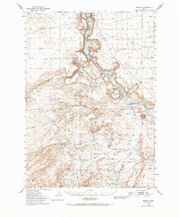
1949 Map of Oreana
USGS Topo · Published 1952About this map
Snake River canyon walls and the surrounding high desert plateaus define this Owyhee County landscape during the late 1940s. The map documents a sparsely populated ranching and passage territory, centered on the small settlement of Oreana and its associated Oreana Sch. Significant historical sites are noted along the river corridor, including the Otter Massacre Site and the trace of the Emigrant Road, which follows the high ground above Sinker Creek. Local land ownership and genealogy are represented through named landmarks like Gatica Ranch, the Jacob Reuben Graves site, and Morgan Place. Water management is critical in this arid environment, evidenced by Artesian Wells, the Foremans Reservoir, and a network of named drainages such as Castle Creek and Catherine Creek that flow toward the river's deep basalt-lined gorge at Swan Falls.
Find a feature on this map
45 named features on this map. Tap any name to fly to it.
Don’t see what you’re looking for? This feature index may not catch every label — zoom into the map to look around manually.
Map Details
Editions of this 1949 Oreana Map
2 editions found
Other maps of this area

1892 · Bisuka
USGS Topo · 1:125,000

1892 · Silver City
USGS Topo · 1:125,000

1894 · Bisuka
USGS Topo · 1:125,000

1894 · Silver City
USGS Topo · 1:125,000

1898 · Silver City
USGS Topo · 1:125,000

1947 · Grand View
USGS Topo · 1:62,500

1947 · Jackass Butte
USGS Topo · 1:24,000

1947 · Wild Horse Butte
USGS Topo · 1:24,000

1947 · Vinson Wash
USGS Topo · 1:24,000

1948 · Castle Butte
USGS Topo · 1:24,000