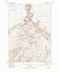
1949 Map of Oreana
USGS Topo · Published 1968About this map
Snake River geography dominates this mid-century survey, revealing a landscape etched by pioneer history and desert hydrology. The canyon walls around Swan Falls and the Snake River corridor are marked by the path of the Emigrant Trail, which traces the benchland above the river. Cultural landmarks like the Otter Massacre Site and Jacob Reuben Graves provide specific points of historical interest for researchers of the western migration era.
Find a feature on this map
39 named features on this map. Tap any name to fly to it.
Don’t see what you’re looking for? This feature index may not catch every label — zoom into the map to look around manually.
Map Details
Editions of this 1949 Oreana Map
2 editions found

Other maps of this area

1892 · Bisuka
USGS Topo · 1:125,000

1892 · Silver City
USGS Topo · 1:125,000

1894 · Bisuka
USGS Topo · 1:125,000

1894 · Silver City
USGS Topo · 1:125,000

1898 · Silver City
USGS Topo · 1:125,000

1947 · Grand View
USGS Topo · 1:62,500

1947 · Jackass Butte
USGS Topo · 1:24,000

1947 · Wild Horse Butte
USGS Topo · 1:24,000

1947 · Vinson Wash
USGS Topo · 1:24,000

1948 · Castle Butte
USGS Topo · 1:24,000