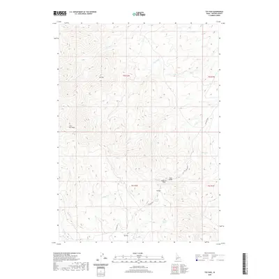
2020 Map of Toy Pass
USGS Topo · Published 2020About this map
Silver City Range dominates the western topography of this Idaho high-country survey, where steep drainages and mountain passes define the local transit corridors. The rugged environment is anchored by Toy Pass and Hyde Saddle, providing critical transit points between the numerous creek systems that carve through the Owyhee County landscape. Water sources are vital here, with several named springs such as Henderson Springs, Charity Spring, and Lineham Spring dotting the terrain. The presence of Toy Flat and the winding Bachman Grade suggest the historical reliance on established trails and routes for navigating these elevations. A network of headwaters including N Fork Castle Cr and Buckaroo Cr flow from the central peaks, illustrating the complex watershed that supports this isolated cattle and mining region.
Find a feature on this map
31 named features on this map. Tap any name to fly to it.
Don’t see what you’re looking for? This feature index may not catch every label — zoom into the map to look around manually.
Map Details
Editions of this 2020 Toy Pass Map
This is the sole edition of this map. No revisions or reprints were ever made.
Other maps of this area

1892 · Bisuka
USGS Topo · 1:125,000

1892 · Silver City
USGS Topo · 1:125,000

1894 · Bisuka
USGS Topo · 1:125,000

1894 · Silver City
USGS Topo · 1:125,000

1898 · Silver City
USGS Topo · 1:125,000

1949 · Oreana
USGS Topo · 1:62,500
1949 · Oreana
USGS Topo · 1:24,000
1950 · Oreana
USGS Topo · 1:24,000

1955 · Jordan Valley
USGS Topo · 1:250,000

1955 · Boise
USGS Topo · 1:250,000