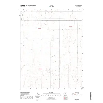
2018 Map of Tractor
USGS Topo · Published 2018About this map
White Woman Basin dominates the western half of this western Kansas landscape, illustrating the unique closed-basin drainage patterns of the High Plains. The small settlement of Tractor sits in the north-central portion of the map, serving as a focal point for the surrounding agricultural network. This 2018 survey reveals a highly organized township and range system, where the section lines are defined by a rhythmic grid of rural roads. Long north-south arteries like S Navaho Rd, N Omaha Rd, and N Pawnee Rd facilitate movement across the open plains, while east-west routes such as E Rd 130 and E Rd 100 connect the various farmstead sites. The map effectively documents the intersection of natural depressions and human-imposed geometry, showing how local infrastructure adapts to the subtle shifts in elevation across t18s r32w and t19s r32w.
Find a feature on this map
25 named features on this map. Tap any name to fly to it.
Don’t see what you’re looking for? This feature index may not catch every label — zoom into the map to look around manually.
Map Details
Editions of this 2018 Tractor Map
This is the sole edition of this map. No revisions or reprints were ever made.
Other maps of this area

1939 · Sandon
USGS Topo · 1:62,500

1940 · Scott City
USGS Topo · 1:62,500

1942 · Sandon
USGS Topo · 1:62,500

1951 · Scott City
USGS Topo · 1:62,500

1955 · Scott City
USGS Topo · 1:250,000

1958 · Scott City
USGS Topo · 1:250,000

1974 · Amy SW
USGS Topo · 1:24,000

1974 · Grigston
USGS Topo · 1:24,000

1974 · Manning
USGS Topo · 1:24,000
1976 · Shallow Water
USGS Topo · 1:24,000