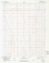
1978 Map of Tractor
USGS Topo · Published 1978About this map
Atchison Topeka and Santa Fe and Missouri Pacific railroad tracks dominate the northern reaches of this Scott County landscape, converging near the small settlement of Tractor. The terrain is defined by broad geographic depressions and basins, most notably the White Woman Basin which occupies the western portion of the sheet. This 1970s survey illustrates a rural Kansas environment where early 20th-century rail infrastructure remained vital alongside a growing energy sector. Scattered throughout the townships of Scott, Keystone, and Lake, numerous sites labeled Oil Well and Gas Well indicate the importance of subsurface resources to the local economy. The map provides a precise look at section lines, windmills, and wells that supported the high plains agricultural lifestyle of the era.
Find a feature on this map
9 named features on this map. Tap any name to fly to it.
Don’t see what you’re looking for? This feature index may not catch every label — zoom into the map to look around manually.
Map Details
Editions of this 1978 Tractor Map
This is the sole edition of this map. No revisions or reprints were ever made.
Other maps of this area

1939 · Sandon
USGS Topo · 1:62,500

1940 · Scott City
USGS Topo · 1:62,500

1942 · Sandon
USGS Topo · 1:62,500

1951 · Scott City
USGS Topo · 1:62,500

1955 · Scott City
USGS Topo · 1:250,000

1958 · Scott City
USGS Topo · 1:250,000

1974 · Amy SW
USGS Topo · 1:24,000

1974 · Grigston
USGS Topo · 1:24,000

1974 · Manning
USGS Topo · 1:24,000
1976 · Shallow Water
USGS Topo · 1:24,000