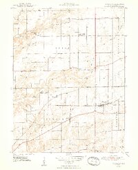
1948 Map of Trafalgar
USGS Topo · Published 1948About this map
Trafalgar serves as a central hub on this mid-century survey of south-central Indiana, where the New York Central and Illinois Central railroads converge. The map documents a landscape transitioning from the heights of Pea Ridge and Turkey Hill down into the intricate drainage of Stotts Creek and its many prongs. Small agrarian communities like Providence, Bud, and Samaria are clearly defined, often centered around local landmarks such as the Union Township Sch or Samaria Ch.
Find a feature on this map
39 named features on this map. Tap any name to fly to it.
Don’t see what you’re looking for? This feature index may not catch every label — zoom into the map to look around manually.
Map Details
Editions of this 1948 Trafalgar Map
2 editions found
Other maps of this area

1942 · Franklin
USGS Topo · 1:125,000

1947 · Franklin
USGS Topo · 1:62,500

1948 · Franklin
USGS Topo · 1:24,000

1948 · Trafalgar
USGS Topo · 1:24,000

1948 · Nineveh
USGS Topo · 1:24,000

1948 · Fruitdale
USGS Topo · 1:24,000

1948 · Morgantown
USGS Topo · 1:24,000

1950 · Morgantown
USGS Topo · 1:24,000

1950 · Franklin
USGS Topo · 1:62,500

1952 · Bargersville
USGS Topo · 1:24,000