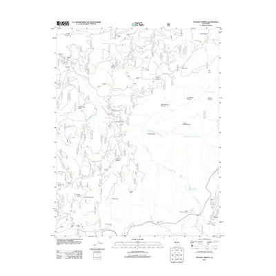
2012 Map of Tragedy Spring
USGS Topo · Published 2012About this map
Tragedy Spring and the surrounding high-elevation meadows define this area of the Sierra Nevada, where water sources like Jim Quinn Spring and Singleton Springs have long dictated movement through the landscape. The 2012 geography is characterized by seasonal camps and recreational hubs, including the Stockton Municipal Camp and the small settlement of Plasse near the shores of Silver Lake. The drainage of the Silver Fork American River cuts through the terrain, joined by tributaries such as Hells Delight Cr and N Tragedy Cr.
Find a feature on this map
49 named features on this map. Tap any name to fly to it.
Don’t see what you’re looking for? This feature index may not catch every label — zoom into the map to look around manually.
Map Details
Editions of this 2012 Tragedy Spring Map
This is the sole edition of this map. No revisions or reprints were ever made.
Other maps of this area

1889 · Pyramid Peak
USGS Topo · 1:125,000

1891 · Pyramid Peak
USGS Topo · 1:125,000

1895 · Pyramid Peak
USGS Topo · 1:125,000

1896 · Pyramid Peak
USGS Topo · 1:125,000

1947 · Sacramento
USGS Topo · 1:250,000

1948 · Sacramento
USGS Topo · 1:250,000

1951 · Leek Spring Hill
USGS Topo · 1:24,000
1951 · Peddler Hill
USGS Topo · 1:24,000
1951 · Leek Spring Hill
USGS Topo · 1:62,500
1952 · Kyburz
USGS Topo · 1:24,000