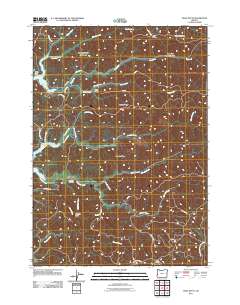
2011 Map of Trail Butte
USGS Topo · Published 2011About this map
Templeton occupies a central position in this part of Coos County, serving as a primary point of reference for the surrounding forested ridges. The Templeton Cemetery remains a significant site for local family history, situated near Johnson Creek and Templeton Arm. The landscape is defined by its complex drainage network, where Palouse Creek and the West Fork Millicoma River flow through deep-cut valleys separated by prominent landmarks like Benson Ridge and Roberts Ridge. To the north, Camp Easter Seal is tucked away near Murphy Creek, while high points such as Tenmile Butte and Trail Butte provide navigational anchors for the dense network of forest service and logging routes, including Scholfield Rd and Dean Mountain Rd.
Find a feature on this map
43 named features on this map. Tap any name to fly to it.
Don’t see what you’re looking for? This feature index may not catch every label — zoom into the map to look around manually.
Map Details
Editions of this 2011 Trail Butte Map
This is the sole edition of this map. No revisions or reprints were ever made.
Other maps of this area

1896 · Coos Bay
USGS Topo · 1:125,000

1898 · Coos Bay
USGS Topo · 1:125,000

1900 · Coos Bay
USGS Topo · 1:125,000

1923 · Reedsport
USGS Topo · 1:62,500

1928 · Sitkum
USGS Topo · 1:125,000

1942 · Reedsport
USGS Topo · 1:62,500

1942 · Coos Bay
USGS Topo · 1:62,500

1945 · Coos Bay
USGS Topo · 1:62,500

1954 · Coos Bay
USGS Topo · 1:250,000

1955 · Scottsburg
USGS Topo · 1:62,500