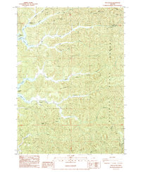
1985 Map of Trail Butte
USGS Topo · Published 1985About this map
Elliott State Forest dominates this coastal Oregon landscape, characterized by a complex network of ridgelines and deep creek drainages that define the border between Douglas and Coos counties. The western edge of the map reveals the intricate shoreline of the lakes, where the North Tenmile Lake and Tenmile Lake extend into several arms, including the Big Creek Arm and Templeton Arm. Small hubs of activity are noted at Camp Easter Seal and the settlement of Templeton, which sits near the confluence of Robertson Creek and Johnson Creek. Significant elevation markers such as Benson Ridge and Roberts Ridge provide a topographical framework for the numerous waterways like Big Creek and Scholfield Creek that carve through the timberlands. The presence of a Hatchery on the creek south of Tenmile Butte points to the area's historical focus on local fishery management and natural resource maintenance.
Find a feature on this map
32 named features on this map. Tap any name to fly to it.
Don’t see what you’re looking for? This feature index may not catch every label — zoom into the map to look around manually.
Map Details
Editions of this 1985 Trail Butte Map
This is the sole edition of this map. No revisions or reprints were ever made.
Other maps of this area

1896 · Coos Bay
USGS Topo · 1:125,000

1898 · Coos Bay
USGS Topo · 1:125,000

1900 · Coos Bay
USGS Topo · 1:125,000

1923 · Reedsport
USGS Topo · 1:62,500

1928 · Sitkum
USGS Topo · 1:125,000

1942 · Reedsport
USGS Topo · 1:62,500

1942 · Coos Bay
USGS Topo · 1:62,500

1945 · Coos Bay
USGS Topo · 1:62,500

1954 · Coos Bay
USGS Topo · 1:250,000

1955 · Scottsburg
USGS Topo · 1:62,500