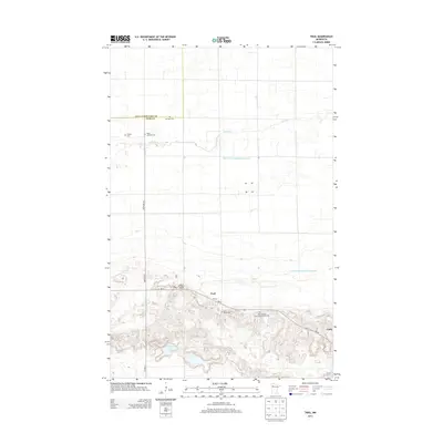
2013 Map of Trail
USGS Topo · Published 2013About this map
The small settlement of Trail anchors this northern Minnesota landscape, situated along the southern bend of MN-92. The terrain is defined by a dense network of drainage infrastructure, such as Judicial Ditch Number Seventytwo and County Ditch Number Eightynine, which manage the low-lying wetlands surrounding the Lost River. This hydraulic engineering reflects the region's agricultural history, reclaiming land for farming between the northern prairie and the southern hills. To the southeast, the village of Gully sits near the base of more varied topography. This area is particularly rich for genealogical research, documenting numerous community burial sites including Mt Olive Cem, Valley Lutheran Cem, and the Saint Charles Borromeo Catholic Cem. In the southwestern corner, Breeze Lake provides a natural break in the engineered landscape, nestled amongst the elevation gains typical of this section of Polk County.
Find a feature on this map
17 named features on this map. Tap any name to fly to it.
Don’t see what you’re looking for? This feature index may not catch every label — zoom into the map to look around manually.
Map Details
Editions of this 2013 Trail Map
This is the sole edition of this map. No revisions or reprints were ever made.
Other maps of this area

1919 · Fosston
USGS Topo · 1:62,500

1919 · Grit
USGS Topo · 1:62,500

1919 · Winsor
USGS Topo · 1:62,500

1954 · Bemidji
USGS Topo · 1:250,000

1957 · Bemidji
USGS Topo · 1:250,000

1958 · Bemidji
USGS Topo · 1:250,000

1969 · Olga
USGS Topo · 1:24,000

1969 · Mc Intosh NE
USGS Topo · 1:24,000

1969 · Gonvick
USGS Topo · 1:24,000
1971 · Oklee
USGS Topo · 1:24,000