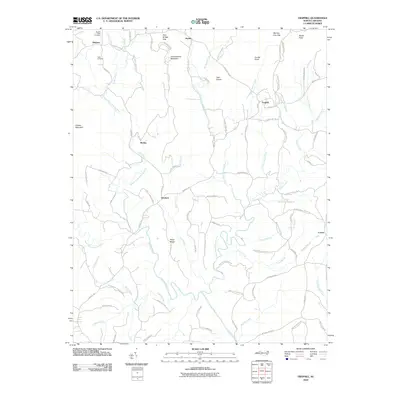
2010 Map of Traphill
USGS Topo · Published 2010About this map
Roaring River and its multiple prongs dominate this landscape in northern Wilkes County, where the Blue Ridge foothills meet the Piedmont. The settlement of Traphill serves as a central point for the surrounding rural communities of Abshers, Dockery, and Joynes. The topography is defined by significant elevations such as Greenstreets Mountain, Combs Knob, and Bucks Peak, while numerous gaps and ridges like Pole Bridge Gap and Wiles Ridge influenced the winding path of local roads.
Find a feature on this map
90 named features on this map. Tap any name to fly to it.
Don’t see what you’re looking for? This feature index may not catch every label — zoom into the map to look around manually.
Map Details
Editions of this 2010 Traphill Map
This is the sole edition of this map. No revisions or reprints were ever made.
Other maps of this area

1889 · Wilkesboro
USGS Topo · 1:125,000

1891 · Wilkesboro
USGS Topo · 1:125,000

1891 · Yadkinville
USGS Topo · 1:125,000

1893 · Yadkinville
USGS Topo · 1:125,000

1953 · Winston-Salem
USGS Topo · 1:250,000

1955 · Winston-Salem
USGS Topo · 1:250,000

1962 · Winston-Salem
USGS Topo · 1:250,000

1966 · Roaring River
USGS Topo · 1:24,000

1966 · Wilkesboro
USGS Topo · 1:24,000
1968 · Glade Valley
USGS Topo · 1:24,000