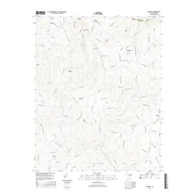
2016 Map of Traphill
USGS Topo · Published 2016About this map
Greenstreets Mtn and Carters Mtn dominate the northern terrain of this Wilkes County landscape, where the Blue Ridge slopes meet the upper basins of the Roaring River. The settlement pattern follows the intricate network of watercourses, with Traphill serving as a central hub for the surrounding rural communities of Joynes, Abshers, and Moxley. These mountain hamlets are connected by a dense web of historically significant routes, including Traphill Mill Rd and Bauguess Mill Rd, suggesting a landscape once defined by local milling and timber operations.
Find a feature on this map
118 named features on this map. Tap any name to fly to it.
Don’t see what you’re looking for? This feature index may not catch every label — zoom into the map to look around manually.
Map Details
Editions of this 2016 Traphill Map
This is the sole edition of this map. No revisions or reprints were ever made.
Other maps of this area

1889 · Wilkesboro
USGS Topo · 1:125,000

1891 · Wilkesboro
USGS Topo · 1:125,000

1891 · Yadkinville
USGS Topo · 1:125,000

1893 · Yadkinville
USGS Topo · 1:125,000

1953 · Winston-Salem
USGS Topo · 1:250,000

1955 · Winston-Salem
USGS Topo · 1:250,000

1962 · Winston-Salem
USGS Topo · 1:250,000

1966 · Roaring River
USGS Topo · 1:24,000

1966 · Wilkesboro
USGS Topo · 1:24,000
1968 · Glade Valley
USGS Topo · 1:24,000