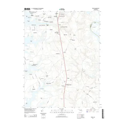
2014 Map of Trappe
USGS Topo · Published 2014About this map
The southern outskirts of Easton and the surrounding Chesapeake Bay tributaries define this portion of the Delmarva Peninsula. The landscape is deeply incised by tidal water bodies such as Peachorchard Cove and Prices Cove, where waterfront settlements like Waverly Island Estates and Peach Orchard have developed. The interior is characterized by a high density of small family or community burial grounds, including the curiously named Hole-in-the Wall Cem and Queen Esther Cem. This pattern suggests a long history of independent farmsteads and rural clusters like Hambleton and Ivytown that predate modern suburban expansion. Further south, the town of Trappe serves as a local hub near La Trappe Heights, while Trappe Landing on Lowry Cove points to the area's historical reliance on maritime transit and commerce along the numerous necks and points of the shoreline.
Find a feature on this map
105 named features on this map. Tap any name to fly to it.
Don’t see what you’re looking for? This feature index may not catch every label — zoom into the map to look around manually.
Map Details
Editions of this 2014 Trappe Map
This is the sole edition of this map. No revisions or reprints were ever made.
Other maps of this area

1898 · Choptank
USGS Topo · 1:125,000

1904 · St. Michaels
USGS Topo · 1:62,500

1904 · Oxford
USGS Topo · 1:62,500

1905 · Denton
USGS Topo · 1:62,500

1905 · Hurlock
USGS Topo · 1:62,500

1908 · Choptank
USGS Topo · 1:125,000

1942 · Oxford
USGS Topo · 1:31,680

1942 · Church Creek
USGS Topo · 1:24,000
1942 · Easton
USGS Topo · 1:24,000
1942 · St. Michaels
USGS Topo · 1:24,000