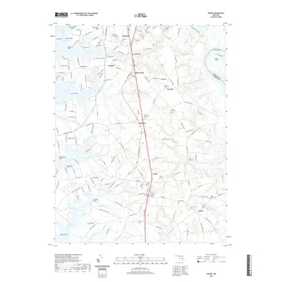
2019 Map of Trappe
USGS Topo · Published 2019About this map
Trappe and its surrounding agricultural lands in Talbot County are defined by an intricate network of tidal estuaries and peninsulas, locally known as necks. This 2019 survey captures a landscape where modern development meets centuries of Maryland Eastern Shore heritage, visible in the numerous small family and community burial grounds like Old Whitemarsh Cem and Queen Esther Cem. The terrain is segmented by waterways such as Peachblossom Creek, Trippe Creek, and Island Creek, which have historically dictated the placement of settlements like Ivytown and Hambleton.
Find a feature on this map
175 named features on this map. Tap any name to fly to it.
Don’t see what you’re looking for? This feature index may not catch every label — zoom into the map to look around manually.
Map Details
Editions of this 2019 Trappe Map
This is the sole edition of this map. No revisions or reprints were ever made.
Other maps of this area

1898 · Choptank
USGS Topo · 1:125,000

1904 · St. Michaels
USGS Topo · 1:62,500

1904 · Oxford
USGS Topo · 1:62,500

1905 · Denton
USGS Topo · 1:62,500

1905 · Hurlock
USGS Topo · 1:62,500

1908 · Choptank
USGS Topo · 1:125,000

1942 · Oxford
USGS Topo · 1:31,680

1942 · Church Creek
USGS Topo · 1:24,000
1942 · Easton
USGS Topo · 1:24,000
1942 · St. Michaels
USGS Topo · 1:24,000