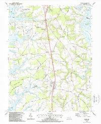
1988 Map of Trappe
USGS Topo · Published 1988About this map
Trappe serves as the central hub for this late-1980s portrait of Talbot County's Eastern Shore, where the landscape is defined by the deep fingers of the Choptank River, Peachblossom Creek, and Island Creek. The map documents a period of transition, where legacy agricultural and maritime infrastructure meets modern additions like a Heliport and a Drive-in Theater near the town center. The presence of an Old Railroad Grade and several distinct necks, including Edmundson Neck and Frazier Neck, reflects the historical reliance on water-and-rail transport for local commerce.
Find a feature on this map
97 named features on this map. Tap any name to fly to it.
Don’t see what you’re looking for? This feature index may not catch every label — zoom into the map to look around manually.
Map Details
Editions of this 1988 Trappe Map
This is the sole edition of this map. No revisions or reprints were ever made.
Other maps of this area

1898 · Choptank
USGS Topo · 1:125,000

1904 · St. Michaels
USGS Topo · 1:62,500

1904 · Oxford
USGS Topo · 1:62,500

1905 · Denton
USGS Topo · 1:62,500

1905 · Hurlock
USGS Topo · 1:62,500

1908 · Choptank
USGS Topo · 1:125,000

1942 · Oxford
USGS Topo · 1:31,680

1942 · Church Creek
USGS Topo · 1:24,000
1942 · Easton
USGS Topo · 1:24,000
1942 · St. Michaels
USGS Topo · 1:24,000