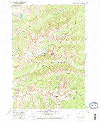
1964 Map of Trapper Peak
USGS Topo · Published 1979About this map
The high alpine peaks and glacial basins of the Bitterroot Mountains define this 1964 survey of the Bitterroot National Forest in Ravalli County. The landscape is dominated by the massive crest of Trapper Peak, which stands as the highest point in the range, flanked by North Trapper Peak and the curiously named The Lonesome Bachelor. The drainages of Tin Cup Creek and Trapper Creek carve deep valleys through the granite, providing paths for the Tin Cup Creek Trail and the Trapper Peak Trail.
Find a feature on this map
29 named features on this map. Tap any name to fly to it.
Don’t see what you’re looking for? This feature index may not catch every label — zoom into the map to look around manually.
Map Details
Editions of this 1964 Trapper Peak Map
3 editions found
Other maps of this area

1901 · Hamilton
USGS Topo · 1:125,000

1956 · Elk City
USGS Topo · 1:250,000

1956 · Hamilton
USGS Topo · 1:250,000

1959 · Hamilton
USGS Topo · 1:250,000

1960 · Elk City
USGS Topo · 1:250,000

1960 · Hamilton
USGS Topo · 1:250,000

1964 · Hamilton
USGS Topo · 1:250,000

1964 · Burnt Ridge
USGS Topo · 1:24,000

1964 · Boulder Peak
USGS Topo · 1:24,000

1964 · Darby
USGS Topo · 1:24,000