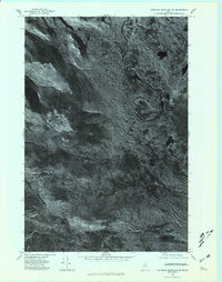
1975 Map of Traveler Mountain SE
USGS Topo · Published 1981About this map
Traveler Mountain and the surrounding peaks of the Maine wilderness are captured in this orthophotograph, providing a literal view of the landscape as it appeared in the mid-1970s. This specific type of survey relies on rectified aerial imagery to show the actual forest cover and terrain relief, moving beyond the abstract lines of a standard topographic sheet. The sharp transition from the heights of Barrell Ridge down to the winding East Branch Penobscot River highlights the natural drainage patterns of this unpopulated region. Geologists and outdoorsmen can observe the distinct drainages of Wassataquoik Stream and the shadowed ridges of Bald Mountain and Sable Mountain, offering a precise record of the timberline and waterway alignments before subsequent decades of forest growth and change.
Find a feature on this map
7 named features on this map. Tap any name to fly to it.
Don’t see what you’re looking for? This feature index may not catch every label — zoom into the map to look around manually.
Map Details
Editions of this 1975 Traveler Mountain SE Map
2 editions found
Other maps of this area

1927 · Katahdin
USGS Topo · 1:48,000

1930 · Katahdin
USGS Topo · 1:62,500

1949 · Katahdin
USGS Topo · 1:62,500

1953 · Stacyville
USGS Topo · 1:62,500

1954 · Shin Pond
USGS Topo · 1:62,500

1954 · Presque Isle
USGS Topo · 1:250,000

1954 · Millinocket
USGS Topo · 1:250,000

1955 · Traveler Mountain
USGS Topo · 1:62,500

1958 · Presque Isle
USGS Topo · 1:250,000

1958 · Millinocket
USGS Topo · 1:250,000