
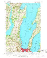
1957 Map of Traverse City
USGS Topo · Published 1958About this map
Old Mission Peninsula divides the deep waters of the West Arm Grand Traverse Bay and the East Arm Grand Traverse Bay, anchoring a landscape defined by fruit orchards and waterfront settlements. In the late 1950s, Traverse City serves as the regional hub, its street grid detailed from Front St to 11th St, featuring landmarks like the Fairground, Airport, and the early campus of Northwestern Michigan College.
Find a feature on this map
85 named features on this map. Tap any name to fly to it.
Don’t see what you’re looking for? This feature index may not catch every label — zoom into the map to look around manually.
Map Details
Editions of this 1957 Traverse City Map
2 editions found
Other maps of this area

1954 · Central Lake
USGS Topo · 1:62,500

1954 · Traverse City
USGS Topo · 1:250,000

1955 · Cheboygan
USGS Topo · 1:250,000

1956 · Fife Lake
USGS Topo · 1:62,500

1956 · Kingsley
USGS Topo · 1:62,500

1956 · Thompsonville
USGS Topo · 1:62,500

1957 · Northport
USGS Topo · 1:62,500

1957 · Maple City
USGS Topo · 1:62,500

1957 · Elk Rapids
USGS Topo · 1:62,500

1958 · Cheboygan
USGS Topo · 1:250,000
Featured Places
- Garfield Township, MI
- Traverse City, MI
- East Bay Township, MI
- Long Lake Township, MI
- Peninsula Township, MI