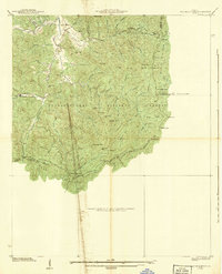
1938 Map of Tray Mountain
USGS Topo · Published 1938About this map
Chattahoochee National Forest dominates this 1938 landscape, where the ridges of the Blue Ridge define the headwaters of the Hiwassee River. The era is marked by the presence of federal work projects, most notably CCC Camp No F-15, located near the southern fork of the river. The Appalachian Trail winds along the high peaks, connecting landmarks like the Mt Airy Shelter and crossing through the high saddle of Unicoi Gap.
Find a feature on this map
55 named features on this map. Tap any name to fly to it.
Don’t see what you’re looking for? This feature index may not catch every label — zoom into the map to look around manually.
Map Details
Editions of this 1938 Tray Mountain Map
3 editions found
Other maps of this area

1886 · Dahlonega
USGS Topo · 1:125,000

1892 · Dahlonega
USGS Topo · 1:125,000

1896 · Dahlonega
USGS Topo · 1:125,000

1903 · Dahlonega
USGS Topo · 1:125,000

1935 · Osborn
USGS Topo · 1:24,000

1935 · Cowrock
USGS Topo · 1:24,000

1935 · Hightower Bald
USGS Topo · 1:24,000

1935 · Tray Mountain
USGS Topo · 1:24,000

1935 · Jacks Gap
USGS Topo · 1:24,000
1935 · Hiawassee
USGS Topo · 1:24,000