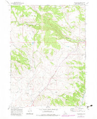
1969 Map of Treasureton
USGS Topo · Published 1983About this map
Treasureton serves as the focal point for this landscape in the Portneuf Range during the late 1960s, a period when the agricultural and water management infrastructure of Franklin County was well established. The map highlights the essential role of irrigation in this high-elevation terrain, specifically through the Cleveland Irrigation Canal and its path near Cleveland Hill. The settlement pattern follows the drainages of Battle Creek and Cottonwood Creek, with numerous springs providing vital water sources for local livestock operations in Stock Valley. Local history is anchored at the Treasureton Cemetery and the site of Oneida Station along the Bear River. The topography is dominated by several named summits, including Treasureton Hill and Rocky Peak, while a network of jeep trails and 4WD tracks suggests a landscape primarily utilized for ranching and resource extraction, evidenced by a Mine and Gravel Pit located within the quadrangle.
Find a feature on this map
21 named features on this map. Tap any name to fly to it.
Don’t see what you’re looking for? This feature index may not catch every label — zoom into the map to look around manually.
Map Details
Editions of this 1969 Treasureton Map
2 editions found
Other maps of this area

1915 · Preston
USGS Topo · 1:96,000

1918 · Preston
USGS Topo · 1:125,000

1955 · Preston
USGS Topo · 1:250,000

1958 · Preston
USGS Topo · 1:250,000

1962 · Preston
USGS Topo · 1:250,000
1969 · Treasureton
USGS Topo · 1:24,000
1969 · Mink Creek
USGS Topo · 1:24,000
1969 · Banida
USGS Topo · 1:24,000
1969 · Cottonwood Peak
USGS Topo · 1:24,000
1969 · Thatcher
USGS Topo · 1:24,000