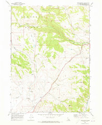
1969 Map of Treasureton
USGS Topo · Published 1973About this map
Treasureton and the surrounding high country of Franklin County are defined by the steep slopes of the Portneuf Range and the meandering path of Cottonwood Creek. In the late 1960s, this landscape supported a modest agricultural and ranching economy, evidenced by the presence of the Cleveland Irrigation Canal and a Gravel Pit near Battle Creek. The geography transitions from the elevated Treasureton Hill down to the banks of the Bear River at Oneida Station, where a gaging station monitored water levels for downstream use. Genealogists will find the Treasureton Cemetery clearly marked on the flats below the foothills. Numerous named springs and jeep trails underscore the importance of water access and mobility across this varied terrain of peaks like Rocky Peak and high valleys like Stock Valley.
Find a feature on this map
20 named features on this map. Tap any name to fly to it.
Don’t see what you’re looking for? This feature index may not catch every label — zoom into the map to look around manually.
Map Details
Editions of this 1969 Treasureton Map
2 editions found
Other maps of this area

1915 · Preston
USGS Topo · 1:96,000

1918 · Preston
USGS Topo · 1:125,000

1955 · Preston
USGS Topo · 1:250,000

1958 · Preston
USGS Topo · 1:250,000

1962 · Preston
USGS Topo · 1:250,000
1969 · Mink Creek
USGS Topo · 1:24,000
1969 · Banida
USGS Topo · 1:24,000
1969 · Cottonwood Peak
USGS Topo · 1:24,000
1969 · Thatcher
USGS Topo · 1:24,000
1969 · Oneida Narrows Reservoir
USGS Topo · 1:24,000