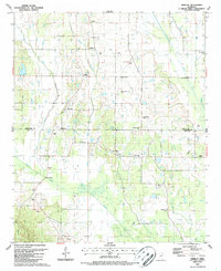
1987 Map of Trebloc
USGS Topo · Published 1987About this map
The rural boundary between Chickasaw Co and Clay Co is defined by a dense network of meandering waterways and small agricultural communities in the late 1980s. The settlement of Trebloc sits near the headwaters of Bogue Culley, while McCondy and Una anchor the central and southern reaches of the map. The landscape is notably dotted with country churches and family-named cemeteries, such as Soul Chapel Cem, Macedonia Ch, and Mixon Cem, which are vital markers for genealogists tracing regional family history. Industry in the area is represented by scattered Oil Wells, Gas Wells, and Quarries that follow the terrain near Houlka Creek. The surveying of several gaging stations along the major creeks indicates the importance of water management in this portion of northeastern Mississippi.
Find a feature on this map
40 named features on this map. Tap any name to fly to it.
Don’t see what you’re looking for? This feature index may not catch every label — zoom into the map to look around manually.
Map Details
Editions of this 1987 Trebloc Map
This is the sole edition of this map. No revisions or reprints were ever made.
Other maps of this area

1953 · West Point
USGS Topo · 1:250,000

1958 · West Point
USGS Topo · 1:250,000

1959 · West Point
USGS Topo · 1:62,500

1959 · Van Vleet
USGS Topo · 1:62,500

1959 · Pheba
USGS Topo · 1:62,500

1963 · West Point
USGS Topo · 1:250,000

1965 · Egypt
USGS Topo · 1:24,000

1966 · Prairie
USGS Topo · 1:24,000

1982 · West Point
USGS Topo · 1:100,000

1984 · West Point
USGS Topo · 1:250,000