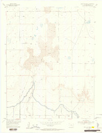
1955 Map of Tree Top Ranch
USGS Topo · Published 1956About this map
Gageby Creek carves a path through the plains of Bent County in this mid-century topographic study, revealing a landscape defined by water management and ranching. The presence of the Tree Top Ranch serves as a primary landmark in a region where survival depends on the intricate network of the Fort Lyon Canal. This mapping includes a decommissioned section of that same watercourse, labeled Fort Lyon Canal (Abandoned), which marks the shifting engineering of the High Plains irrigation systems.
Find a feature on this map
12 named features on this map. Tap any name to fly to it.
Don’t see what you’re looking for? This feature index may not catch every label — zoom into the map to look around manually.
Map Details
Editions of this 1955 Tree Top Ranch Map
2 editions found
Other maps of this area

1891 · Las Animas
USGS Topo · 1:125,000

1892 · Lamar
USGS Topo · 1:125,000

1893 · Las Animas
USGS Topo · 1:125,000

1953 · Hasty
USGS Topo · 1:24,000

1953 · Las Animas
USGS Topo · 1:24,000

1953 · Kreybill
USGS Topo · 1:24,000

1954 · Lamar
USGS Topo · 1:250,000

1955 · Tree Top Ranch
USGS Topo · 1:24,000

1955 · Lubers
USGS Topo · 1:24,000

1955 · Bishop Ranch
USGS Topo · 1:24,000