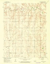
1960 Map of Trego Center
USGS Topo · Published 1962About this map
Big Creek winds through the northern portion of this High Plains landscape, where the shifting courses of East Branch and Downer Creek carve into the upland plateaus. This 1960 survey reflects a deeply rural Kansas community organized by the township system, divided between Wakeeney and Collyer. The map reveals a network of country schools that served as local anchors, including Montrose Sch, Excelsior Sch, and Boena Sch. At the crossroads of Trego Center, the presence of Zion Cem and scattered Gravel Pit workings point to a local economy and social life tied closely to the land and the maintenance of the section-line road grid. The topography, mapped as part of the Missouri River Basin development program, provides a clear view of the drainage patterns essential to agriculture in Trego County.
Find a feature on this map
12 named features on this map. Tap any name to fly to it.
Don’t see what you’re looking for? This feature index may not catch every label — zoom into the map to look around manually.
Map Details
Editions of this 1960 Trego Center Map
This is the sole edition of this map. No revisions or reprints were ever made.
Other maps of this area

1893 · Ellis
USGS Topo · 1:125,000

1893 · Hill
USGS Topo · 1:125,000

1954 · Goodland
USGS Topo · 1:250,000

1955 · Great Bend
USGS Topo · 1:250,000

1955 · Scott City
USGS Topo · 1:250,000

1955 · Beloit
USGS Topo · 1:250,000

1956 · Goodland
USGS Topo · 1:250,000

1957 · Goodland
USGS Topo · 1:250,000

1957 · Great Bend
USGS Topo · 1:250,000

1958 · Great Bend
USGS Topo · 1:250,000