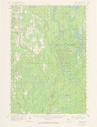
1958 Map of Trenary
USGS Topo · Published 1968About this map
The settlement of Trenary sits at a critical junction in the Upper Peninsula, where the Minneapolis St Paul and Sault Ste Marie railroad cuts across the timberlands of Delta and Alger counties. This mid-century survey reveals a landscape defined by its water and forestry resources, with the village itself serving as a local hub near the Trenary Lookout Tower. To the east and south, the terrain is dominated by the dense woodlands of the Hiawatha National Forest and the Escanaba River State Forest, fragmented by a complex network of glacial lakes and streams.
Find a feature on this map
47 named features on this map. Tap any name to fly to it.
Don’t see what you’re looking for? This feature index may not catch every label — zoom into the map to look around manually.
Map Details
Editions of this 1958 Trenary Map
3 editions found

Other maps of this area

1932 · Gladstone NE
USGS Topo · 1:31,680

1932 · Rapid River NE
USGS Topo · 1:31,680

1932 · Trenary SW
USGS Topo · 1:31,680

1932 · Garden NW and SW
USGS Topo · 1:31,680

1932 · Rock NE
USGS Topo · 1:31,680

1932 · Skandia SE
USGS Topo · 1:31,680

1932 · Rapid River NW
USGS Topo · 1:31,680

1932 · Trenary SE
USGS Topo · 1:31,680

1932 · Rock SE
USGS Topo · 1:31,680

1932 · Skeels Lake NW and SW
USGS Topo · 1:31,680
Featured Places
- Nahma Township, MI
- Au Train Township, MI
- Mathias Township, MI
- Baldwin Township, MI
- Limestone Township, MI