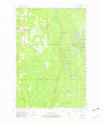
1958 Map of Trenary
USGS Topo · Published 1982About this map
Trenary sits at the junction of northern Michigan’s forest lands and early road networks, serving as the primary hub for this portion of the Upper Peninsula. Surveyed in the late 1950s, the landscape is defined by the heavy conservation presence of the Hiawatha National Forest and the Escanaba River State Forest. The geography is intricately carved by the Sturgeon River and the East Branch Whitefish River, which feed a dense network of smaller lakes including Paquette Lake and Lake Stella.
Find a feature on this map
50 named features on this map. Tap any name to fly to it.
Don’t see what you’re looking for? This feature index may not catch every label — zoom into the map to look around manually.
Map Details
Editions of this 1958 Trenary Map
3 editions found

Other maps of this area

1932 · Gladstone NE
USGS Topo · 1:31,680

1932 · Rapid River NE
USGS Topo · 1:31,680

1932 · Trenary SW
USGS Topo · 1:31,680

1932 · Garden NW and SW
USGS Topo · 1:31,680

1932 · Rock NE
USGS Topo · 1:31,680

1932 · Skandia SE
USGS Topo · 1:31,680

1932 · Rapid River NW
USGS Topo · 1:31,680

1932 · Trenary SE
USGS Topo · 1:31,680

1932 · Rock SE
USGS Topo · 1:31,680

1932 · Skeels Lake NW and SW
USGS Topo · 1:31,680
Featured Places
- Nahma Township, MI
- Au Train Township, MI
- Mathias Township, MI
- Baldwin Township, MI
- Limestone Township, MI