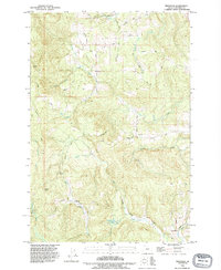
1990 Map of Trenholm
USGS Topo · Published 1995About this map
The timbered uplands of Columbia County take center stage in this 1990 revision, where the headwaters of the Clatskanie River and Milton Creek carve through the landscape. The small settlement of Trenholm serves as a local crossroads at the intersection of Trenholm Road and Pittsburg St Helens Road. To the north, the community of Beaver Homes and the nearby Whitney Basin illustrate the area's established rural character. The map details an extensive network of logging and access roads, such as Meissner Road and Canaan Road, which reflect the region's enduring connection to the forestry industry.
Find a feature on this map
43 named features on this map. Tap any name to fly to it.
Don’t see what you’re looking for? This feature index may not catch every label — zoom into the map to look around manually.
Map Details
Editions of this 1990 Trenholm Map
This is the sole edition of this map. No revisions or reprints were ever made.
Other maps of this area

1919 · Mayger
USGS Topo · 1:62,500

1921 · Kalama
USGS Topo · 1:62,500

1922 · St. Helens
USGS Topo · 1:62,500

1940 · Vernonia
USGS Topo · 1:62,500

1941 · St Helens
USGS Topo · 1:62,500

1941 · Clatskanie
USGS Topo · 1:62,500

1943 · Vernonia
USGS Topo · 1:62,500

1943 · St Helens
USGS Topo · 1:62,500

1948 · Vancouver
USGS Topo · 1:250,000

1950 · Vancouver
USGS Topo · 1:250,000