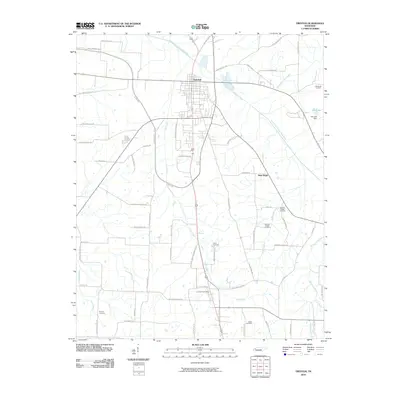
2010 Map of Trenton
USGS Topo · Published 2010About this map
Trenton serves as the central hub for this portion of Gibson County, where the North Fork Forked Deer River winds through a landscape of agricultural plots and drainage systems. The town’s transition from a historic core to modern industrial expansion is evident along Manufacturers Row and Industrial Park Dr, while the surrounding countryside preserves older settlement patterns. Numerous small burial grounds, including Whitehall Cemetery and Harpers Chapel Cemetery, are scattered across the landscape, serving as vital touchstones for family historians and genealogists tracking local ancestry.
Find a feature on this map
63 named features on this map. Tap any name to fly to it.
Don’t see what you’re looking for? This feature index may not catch every label — zoom into the map to look around manually.
Map Details
Editions of this 2010 Trenton Map
This is the sole edition of this map. No revisions or reprints were ever made.
Other maps of this area

1951 · Trenton
USGS Topo · 1:24,000

1952 · Milan
USGS Topo · 1:24,000

1953 · Dyer
USGS Topo · 1:24,000

1954 · Bradford
USGS Topo · 1:24,000

1956 · Dyersburg
USGS Topo · 1:250,000

1956 · Blytheville
USGS Topo · 1:250,000

1959 · Medina
USGS Topo · 1:24,000

1959 · Blytheville
USGS Topo · 1:250,000

1959 · Humboldt
USGS Topo · 1:24,000
1964 · Alamo
USGS Topo · 1:24,000