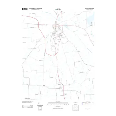
2013 Map of Trenton
USGS Topo · Published 2013About this map
The N Fork Forked Deer River defines the northern and eastern reaches of this landscape, winding past the county seat of Trenton. This 2013 survey illustrates the modern layout of the town, where a concentration of industry is evidenced by S Manufacturers Row and a central Industrial Park Dr. Beyond the municipal center, the map reveals a rural network of roads often named for the families and community landmarks they once served, such as McRee Schoolhouse Rd, Willis School Rd, and Gale Faucett Rd. In the southern portion of the quadrangle, the small settlements of Fruitland and Edison sit along the primary corridors connecting the region's agricultural lands. The presence of Christian Chapel and New Hope highlights established local gathering points that have anchored these Gibson County communities for generations.
Find a feature on this map
109 named features on this map. Tap any name to fly to it.
Don’t see what you’re looking for? This feature index may not catch every label — zoom into the map to look around manually.
Map Details
Editions of this 2013 Trenton Map
This is the sole edition of this map. No revisions or reprints were ever made.
Other maps of this area

1951 · Trenton
USGS Topo · 1:24,000

1952 · Milan
USGS Topo · 1:24,000

1953 · Dyer
USGS Topo · 1:24,000

1954 · Bradford
USGS Topo · 1:24,000

1956 · Dyersburg
USGS Topo · 1:250,000

1956 · Blytheville
USGS Topo · 1:250,000

1959 · Medina
USGS Topo · 1:24,000

1959 · Blytheville
USGS Topo · 1:250,000

1959 · Humboldt
USGS Topo · 1:24,000
1964 · Alamo
USGS Topo · 1:24,000